
Publication date: 2019-11-30
Buy Edmonton City Canada Low-poly 3D model
$79.6
License: Royalty Free
Rigged
PBR
Realtime
Animated
Free
Renders and source materials belong to the author kcg.
Specifications
- Platform
- cgtrader
- Animated
- Rigged
- 3D Print ready
- VR / AR / Low-poly
- PBR
- Textures
- Materials
- UV Mapping
- Polygons
- 6929457
- Vertices
- 10140734
- Geometry
- Polygon mesh
Usage recommendations
Realtime rendering
✓
PC Game development
✓
Mobile Game Development
✕
VR/AR applications
✕
Visualisation
✕
Cinema
✕
Advertising
✕
3D Printing
✕
CAD Engineering
✕
E-Commerce & Interactive 3D Web
✕
FAQ
Is this a free 3D model?
No, this model costs $79.6.
How do I download this 3D model?
This model is available through the "Go to purchase" button on this page.
What license applies to this model?
This model is distributed under the Royalty Free license. Click "Go to purchase" for full license details.
Does it include rigging and animation?
This model has no rig or animation. It is a static 3D object.
Does this model have UV mapping?
Yes, this model has UV mapping. Check the Specifications block for technical details and Additional information for the full picture.
What textures and materials does this 3D model include?
This model has textures and materials. Check the Specifications block for technical details and Additional information for the full picture.
Can I use it for 3D printing?
No, this model is not intended for 3D printing.
Additional information
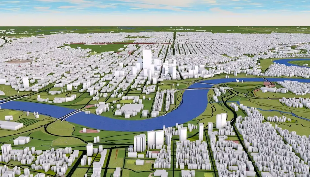
3D representation of Edmonton City Canada using 2019 map data. Roads, railway, land, water, buildings are made using real world data. Buildings are accurately placed and resembles the real world object up to some extend. Please note that random buildings (varying height) are added to those area where real world data is not available.
Clean heirarchy- Proper grouping according to the type of real world objects. Properly named objects and materials. Clean Flat UV map- Properly unwrapped UV for most of the objects. Some objects may have cubic mapping applied. Buildings are extracted from real world data. There are random buildings added to some areas where real world data is partially available (missing height details).
Scene include following groups/objects (depending on the original data some parts may be missing)
AERIALWAY
AEROWAY
aerodrome apron taxiway terminal
BARRIER
BOUNDARY
BUILDING
random apartments farm hotel house detached residential dormitory terrace houseboat bungalow static_caravan cabin commercial office industrial retail etc.
HIGHWAY motorway trunk primary secondary tertiary unclassified residential motorway trunk primary secondary tertiary living street service pedestrian track bus guideway escape raceway road Paths footway bridleway steps cycleway construction proposed rest area
HISTORIC
LANDUSE
commercial construction industrial residential retail
MANMADE bridge
NATURAL wood tree_row tree scrub heath moor grassland
PLACE
RAILWAY
abandoned construction disused funicular light_rail miniature monorail narrow gauge preserved rail subway tram TOURISM
WATERWAY river riverbank stream wadi drystream canal drain ditch fairway dock boatyard dam weir streamend waterfall lockgate
You can easily hide any layer/groups for better visualization. Due to small size and minimum details this scene can be easily loaded. Materials can easily be changed and altered. Adding texture is easy, thanks to unique materials for each sections. Map data : OpenStreetMap contributors
3d scene scale : 1:1 Scene unit: cm
Clean heirarchy- Proper grouping according to the type of real world objects. Properly named objects and materials. Clean Flat UV map- Properly unwrapped UV for most of the objects. Some objects may have cubic mapping applied. Buildings are extracted from real world data. There are random buildings added to some areas where real world data is partially available (missing height details).
Scene include following groups/objects (depending on the original data some parts may be missing)
AERIALWAY
AEROWAY
aerodrome apron taxiway terminal
BARRIER
BOUNDARY
BUILDING
random apartments farm hotel house detached residential dormitory terrace houseboat bungalow static_caravan cabin commercial office industrial retail etc.
HIGHWAY motorway trunk primary secondary tertiary unclassified residential motorway trunk primary secondary tertiary living street service pedestrian track bus guideway escape raceway road Paths footway bridleway steps cycleway construction proposed rest area
HISTORIC
LANDUSE
commercial construction industrial residential retail
MANMADE bridge
NATURAL wood tree_row tree scrub heath moor grassland
PLACE
RAILWAY
abandoned construction disused funicular light_rail miniature monorail narrow gauge preserved rail subway tram TOURISM
WATERWAY river riverbank stream wadi drystream canal drain ditch fairway dock boatyard dam weir streamend waterfall lockgate
You can easily hide any layer/groups for better visualization. Due to small size and minimum details this scene can be easily loaded. Materials can easily be changed and altered. Adding texture is easy, thanks to unique materials for each sections. Map data : OpenStreetMap contributors
3d scene scale : 1:1 Scene unit: cm
Similar models
Find the models you need