
Publication date: 2022-06-11
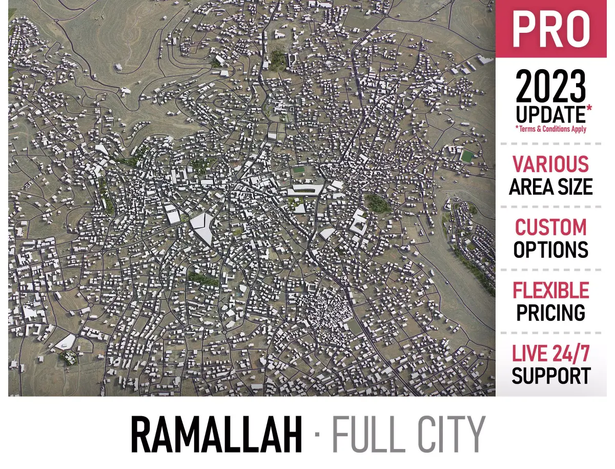
Buy Ramallah Low-poly 3D model
$399
License: Royalty Free
Rigged
PBR
Realtime
Animated
Free

author:
3D-City-Models
Renders and source materials belong to the author 3D-City-Models.
Specifications
- Platform
- cgtrader
- Animated
- Rigged
- 3D Print ready
- VR / AR / Low-poly
- PBR
- Textures
- Materials
- UV Mapping
- Polygons
- 1
- Vertices
- 1
- Geometry
- Polygon mesh
Usage recommendations
Realtime rendering
✓
PC Game development
✓
Mobile Game Development
✓
VR/AR applications
✓
Visualisation
✕
Cinema
✕
Advertising
✕
3D Printing
✕
CAD Engineering
✕
E-Commerce & Interactive 3D Web
✓
FAQ
Is this a free 3D model?
No, this model costs $399.
How do I download this 3D model?
To purchase this model, click the "Go to purchase" button.
What license applies to this model?
This model comes with a Royalty Free license. See the seller's page (via "Go to purchase") for the full terms.
Does it include rigging and animation?
This model has no rig or animation. It is a static 3D object.
Does this model have UV mapping?
Yes, this model has UV mapping. Full specs are available in the Specifications block.
What textures and materials does this 3D model include?
This model has textures and materials, including PBR. Full specs are available in the Specifications block.
Can I use it for 3D printing?
No, this model is not intended for 3D printing.
Additional information
TRY BEFORE YOU BUY
Send us a message to get a test scene of this product
Download a generic sample - www.each.city/sample
WHAT IS INCLUDED
DETAILS
Coordinate reference system - Israel 1993 / Israeli TM Grid (EPSG:2039)
Scene size - Full city extents (refer to images for exact scene size)
Units - Meters
Scale - 1 : 1
Updated - November 2022
KEY BENEFITS
24/7 customer support
Extensive file format support (max, fbx, obj, dae, skp, 3dm, rvt, blend and more)
Any scene size or crop to area-of-interest — for best performance and format compatibility (request before paying)
Buildings, landuse areas, roads and railways split by type (layers / named objects)
Detailed landmarks with the regular updates and improvements
High-resolution surface texture (1 meter resolution satellite image)
The surface is flat, easy to add details and edit geometry
Realistic low-poly trees and forests
Product is ready to render out-of-the-box (3ds Max + Corona Render)
PRESENTATION IMAGES
4K high-resolution renders (refer to images for level of detail and scene size)
Produced in 3ds Max (other software requires its own rendering settings)
MATERIALS
Trees, vegetation, landuse and airport surface with the textures assigned
Buildings are UV mapped, split by material IDs, no textures assigned
2023 UPDATE
TERMS & CONDITIONS
Only applies to new customers who placed an order through the HIRE ME option
Fully customizable model based on the options listed below
Fast turnaround, flexible pricing and discounts
SCENE SIZE
Full city extents up to 100 x 100 km — or crop to the area of interest for better format compability and scene performance
Extended area up to 1000 x 1000 km — or any size options or slice to tiles
MOST ACTUAL DATA
100% real buildings coverage — unlike other sellers we don’t use AI generated building footprints
Combining multiple sources — you may povide us with any dataset to include in the model
GEOREFERENCING
Correct coordinate reference system — unlike other sellers we use only original reference system for each city
Geospatial anchors — allows you to place 3D content at any given latitude and longitude
TOPOGRAPHY TERRAIN
Up to 1 meter accuracy digital terrain model (DTM) — quad mesh
Multiple terrain LODs — triangle mesh optimized for the best polycount / details balance
Buildings and roads placed on the optimized terrain
Separate land surface and water bodies
High-resolution satellite or surface texture — up to 0.2 meter accuracy
Contour lines — 3D splines, up to 1 meter interval
MANUAL MODELING
Buildings and structures — LOD2 and LOD3
Elevated highways — interchanges, bridges and flyovers
TEXTURING
High-resolution surface texture — satellite image up to 0.5 meter accuracy
Streets and roads with markings texture — UV mapped along the center line
Procedural textures assigned to all buildings — LOD1 only
Realistic textures on individual buildings — LOD2 and LOD3
TREES & FORESTS
Individual trees — real trees from OSM data
Procedural forests — based on distribution areas, convertible to individual trees
OTHER EXTRAS
Individual buildings and streets — separate objects with address and/or name
Administrative boundaries of all levels — named polygons or outlines
Road and railway splines — for traffic animation, etc.
Public transport stops — individual named objects
FILE FORMATS
max — Autodesk 3ds Max
fbx, obj, dae, 3ds — Exchange Formats
glb, gltf — Games, Web, AR/VR
unitypackage — Unity 3D
uproject — Unreal Engine
3dm — Rhino 3D
skp — SketchUp
rvt — Autodesk Revit
c4d — Cinema4D
blend — Blender
ma, mb — Autodesk Maya
dwg, dxf — Autodesk AutoCAD
IMPORTANT NOTE
Any options under 2023 UPDATE section can only be ordered using the HIRE ME — flexible pricing applies
Send us a message to get a test scene of this product
Download a generic sample - www.each.city/sample
WHAT IS INCLUDED
DETAILS
Coordinate reference system - Israel 1993 / Israeli TM Grid (EPSG:2039)
Scene size - Full city extents (refer to images for exact scene size)
Units - Meters
Scale - 1 : 1
Updated - November 2022
KEY BENEFITS
24/7 customer support
Extensive file format support (max, fbx, obj, dae, skp, 3dm, rvt, blend and more)
Any scene size or crop to area-of-interest — for best performance and format compatibility (request before paying)
Buildings, landuse areas, roads and railways split by type (layers / named objects)
Detailed landmarks with the regular updates and improvements
High-resolution surface texture (1 meter resolution satellite image)
The surface is flat, easy to add details and edit geometry
Realistic low-poly trees and forests
Product is ready to render out-of-the-box (3ds Max + Corona Render)
PRESENTATION IMAGES
4K high-resolution renders (refer to images for level of detail and scene size)
Produced in 3ds Max (other software requires its own rendering settings)
MATERIALS
Trees, vegetation, landuse and airport surface with the textures assigned
Buildings are UV mapped, split by material IDs, no textures assigned
2023 UPDATE
TERMS & CONDITIONS
Only applies to new customers who placed an order through the HIRE ME option
Fully customizable model based on the options listed below
Fast turnaround, flexible pricing and discounts
SCENE SIZE
Full city extents up to 100 x 100 km — or crop to the area of interest for better format compability and scene performance
Extended area up to 1000 x 1000 km — or any size options or slice to tiles
MOST ACTUAL DATA
100% real buildings coverage — unlike other sellers we don’t use AI generated building footprints
Combining multiple sources — you may povide us with any dataset to include in the model
GEOREFERENCING
Correct coordinate reference system — unlike other sellers we use only original reference system for each city
Geospatial anchors — allows you to place 3D content at any given latitude and longitude
TOPOGRAPHY TERRAIN
Up to 1 meter accuracy digital terrain model (DTM) — quad mesh
Multiple terrain LODs — triangle mesh optimized for the best polycount / details balance
Buildings and roads placed on the optimized terrain
Separate land surface and water bodies
High-resolution satellite or surface texture — up to 0.2 meter accuracy
Contour lines — 3D splines, up to 1 meter interval
MANUAL MODELING
Buildings and structures — LOD2 and LOD3
Elevated highways — interchanges, bridges and flyovers
TEXTURING
High-resolution surface texture — satellite image up to 0.5 meter accuracy
Streets and roads with markings texture — UV mapped along the center line
Procedural textures assigned to all buildings — LOD1 only
Realistic textures on individual buildings — LOD2 and LOD3
TREES & FORESTS
Individual trees — real trees from OSM data
Procedural forests — based on distribution areas, convertible to individual trees
OTHER EXTRAS
Individual buildings and streets — separate objects with address and/or name
Administrative boundaries of all levels — named polygons or outlines
Road and railway splines — for traffic animation, etc.
Public transport stops — individual named objects
FILE FORMATS
max — Autodesk 3ds Max
fbx, obj, dae, 3ds — Exchange Formats
glb, gltf — Games, Web, AR/VR
unitypackage — Unity 3D
uproject — Unreal Engine
3dm — Rhino 3D
skp — SketchUp
rvt — Autodesk Revit
c4d — Cinema4D
blend — Blender
ma, mb — Autodesk Maya
dwg, dxf — Autodesk AutoCAD
IMPORTANT NOTE
Any options under 2023 UPDATE section can only be ordered using the HIRE ME — flexible pricing applies
Similar models
Find the models you need